Section 5. Taking a bearing from the map and following it
What is a bearing?
A bearing is the direction from one point to another, expressed as an angle in degrees from north. On a map, this direction can be represented by a straight line connecting the two points.
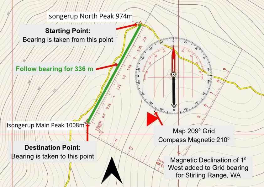
The diagram shows a practical example between Isongerup North Peak and Isongerup Main Peak. The bearing begins at the marked starting point and runs directly to the destination point at Isongerup Main Peak, a straight line distance of approximately 336 metres.
Measured against the map grid, the bearing line between these two points is 209° Grid. With 1° west magnetic declination applied for the Stirling Range, this becomes 210° Magnetic, the bearing that can be transferred to the compass for use in the field.
The image also illustrates an important distinction between a bearing and the route you actually follow. The green bearing line is simply the direct straight line direction from the starting point to the summit of Isongerup Main Peak. The yellow line is the track you actually follow on the ground.
As the image shows, the track bends and changes direction to negotiate the terrain rather than following the straight bearing line. Where an established track exists, the track should be followed rather than attempting to walk directly along the bearing. The bearing provides a directional reference to your destination; it does not necessarily represent a safe or appropriate route to reach it.
Those two points could be your current location and your intended destination, two known locations on the map, or a recognisable landscape feature being used to help determine your position.
Importantly, you do not need to be physically in the field to take a bearing from a map. You can plan an entire journey from home by identifying locations on the map, measuring bearings between them and recording those bearings before your trip begins. Once in the field, those pre planned grid bearings can be converted to magnetic bearings, if required, and used with your compass.
Throughout this guide, bearings are used for two main purposes: to navigate towards a destination and to help determine your location. Although the techniques differ, they rely on the same fundamental principle:
A bearing describes the direction from one point to another. It does not necessarily describe the route you should follow between them.
When would you use this technique?
Taking a bearing from the map is useful for establishing the direction of a known destination, even when the bearing line itself is not the route you intend to follow.
In the Isongerup example above, the direct bearing from Isongerup North Peak to Isongerup Main Peak is 209° Grid, or 210° Magnetic. However, the established track, shown in yellow, does not follow this straight line. It bends around the terrain before reaching the summit. The track should be followed wherever it can be identified, with the bearing providing a useful directional reference towards your destination.
This becomes particularly valuable if the track becomes difficult to identify, as can occur in sections of the Stirling Ridge Walk. Knowing that Isongerup Main Peak lies on a bearing of approximately 210° Magnetic allows you to confirm that you are still generally moving in the correct direction while searching for or relocating the track.
Other situations where a map bearing can be useful include:
confirming your direction when a track becomes indistinct
navigating through low visibility, cloud or mist
crossing broad saddles where the route may be difficult to identify
locating a Navigation Point or other known feature
confirming the correct direction after leaving a recognisable landmark
A bearing therefore does not necessarily tell you where to walk in a straight line. It tells you where your destination lies, providing a directional reference that can be used alongside the track, contours and surrounding terrain.
Taking a Bearing from the Map
Before taking a bearing from the map, you should:
Know your current location.
Identify your destination.
Ensure you can clearly identify the map’s north–south grid lines.
Place the map on as flat a surface as possible and ensure the compass baseplate is also lying flat against the map. Remove mobile phones and keep all metal objects well away from the compass before taking a bearing. Metal objects can interfere with the magnetic needle and reduce the accuracy of your navigation. This simple precaution helps ensure you obtain the most accurate bearing possible.
Practical Tip
Remember that you do not need to be physically in the field to take a bearing from a map. You can plan your entire route from home by identifying known locations on the map, taking bearings between them, and recording them before your trip begins. Once in the field, those pre planned bearings can be transferred to your compass and followed on the ground.
Throughout this guide, the same principle is also used when determining your location using resection. Whether you are planning a route, navigating to a destination, or locating your position, a bearing always represents the direction between two points.
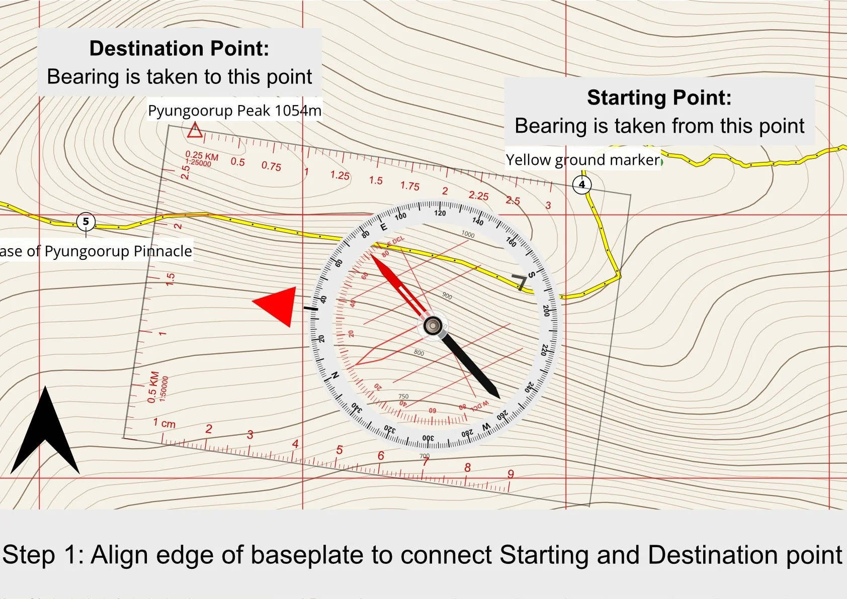
Step 1 :
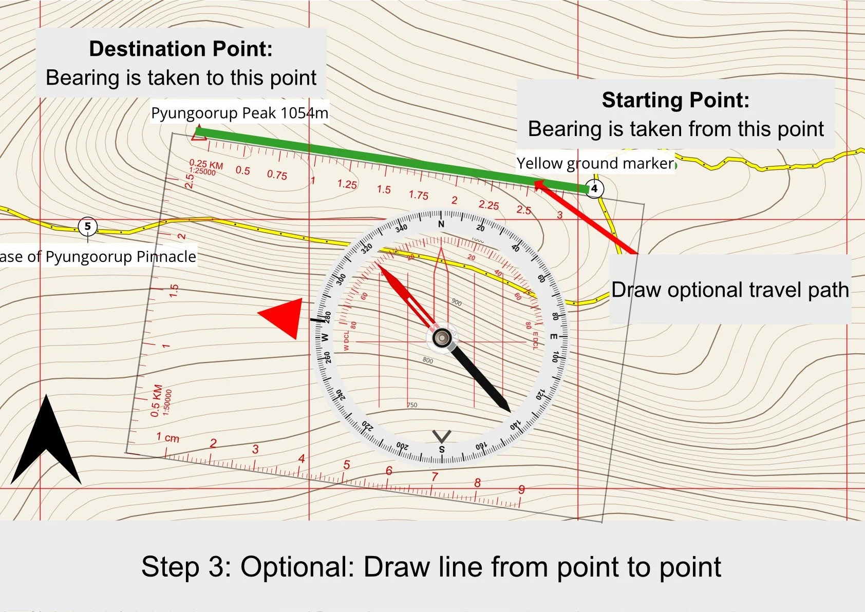
Lay the compass on the map with one long edge of the baseplate connecting the starting point to the intended destination. Ensure the Direction of Travel arrow points towards the intended destination.
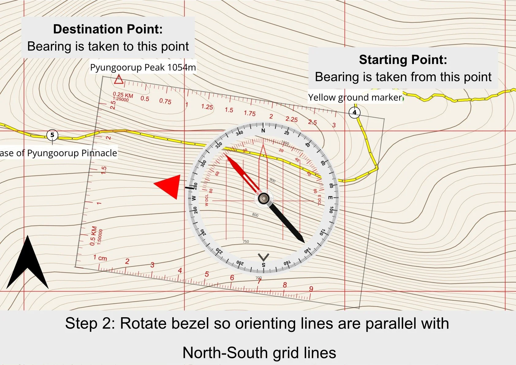
Step 2:
Rotate the compass bezel until the orienting lines are parallel with the map's north–south grid lines. When correctly aligned, the orienting arrow will also be pointing towards Grid North. Note: you do not require “Red in Shed”
Step 3:
Optional: Draw line from point to point and note grid bearing shown at bearing index
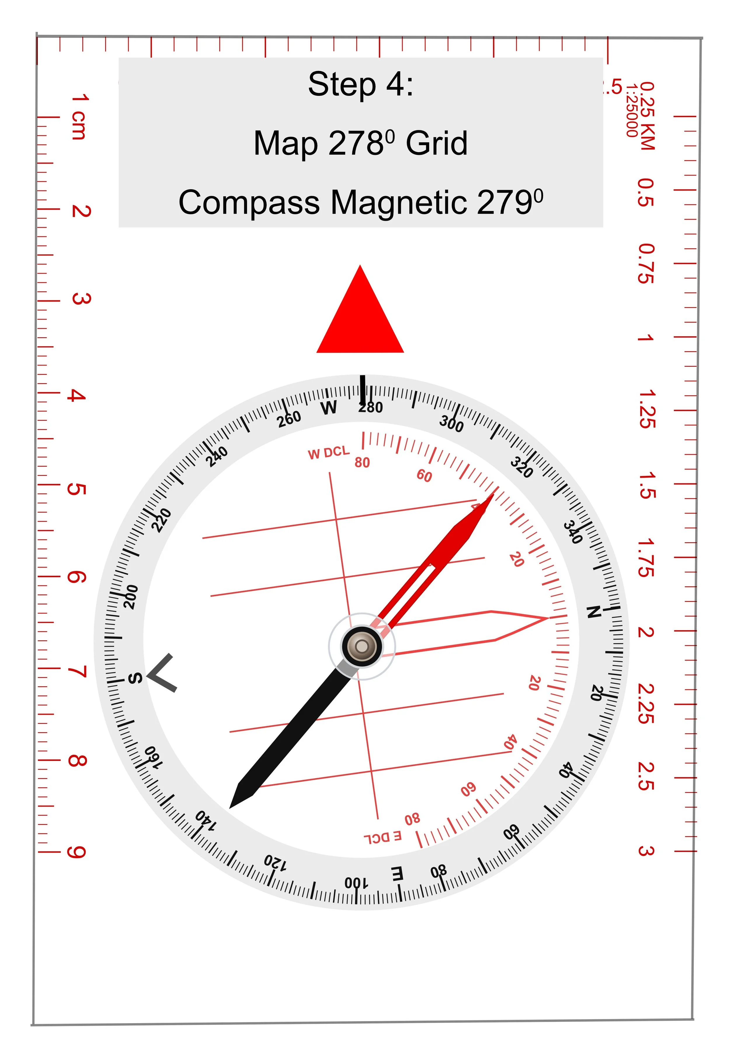
Step 4:
Read the bearing at the bearing index.
If your compass has been adjusted for the local magnetic declination, the bearing is ready to follow. If not, apply the appropriate magnetic declination before navigating on your bearing line. The diagram below shows addition of 1° West Magnetic Declination to the Grid bearing of 278° to give a magnetic bearing of 279°. In the field you follow the magnetic bearing to ensure accuracy when required.