Distance and Timings
Recorded Walking Times
The times shown here are based on multiple actual recorded journeys along the SRW from the Ellen Peak Trailhead towards Bluff Knoll. They are intended to provide a practical indication of how long different sections of the route can take rather than establish a timetable that walkers should expect to follow.
Most of the recorded journeys were undertaken as two night trips with multi day packs generally weighing around 15 kilograms. They broadly consisted of a longer first day, usually travelling through to 3rd Arrow Cave, followed by a shorter second day to Eucalyptus Col Campsite. The final day continued over Bluff Knoll Summit and down to Bluff Knoll Car Park. The recorded section times principally represent moving time. Longer stops such as lunch breaks are not included, although the normal short interruptions associated with travelling along the Ridge inevitably form part of the records.
There are many reasons why the same section can take a different amount of time from one journey to another. A solo walker moving efficiently may travel considerably faster than a group, while other journeys may involve more time examining the terrain or stopping for water. Weather and vegetation can alter the rate of progress, and the effect of carrying a multi day pack becomes more noticeable as fatigue develops. Difficult navigation can also consume a surprising amount of time without adding much distance to the journey.
The average times should therefore be understood as averages drawn from journeys undertaken under different circumstances. Some recorded trips were faster and others considerably slower. They provide a useful indication of the time that has actually been required to travel each section rather than a prediction of how long a particular walker or group will take.
The fastest recorded time provides a different reference. It shows what has actually been achieved through each section when progress was particularly efficient. It should not be treated as a target or as the fastest time in which that section could theoretically be completed.
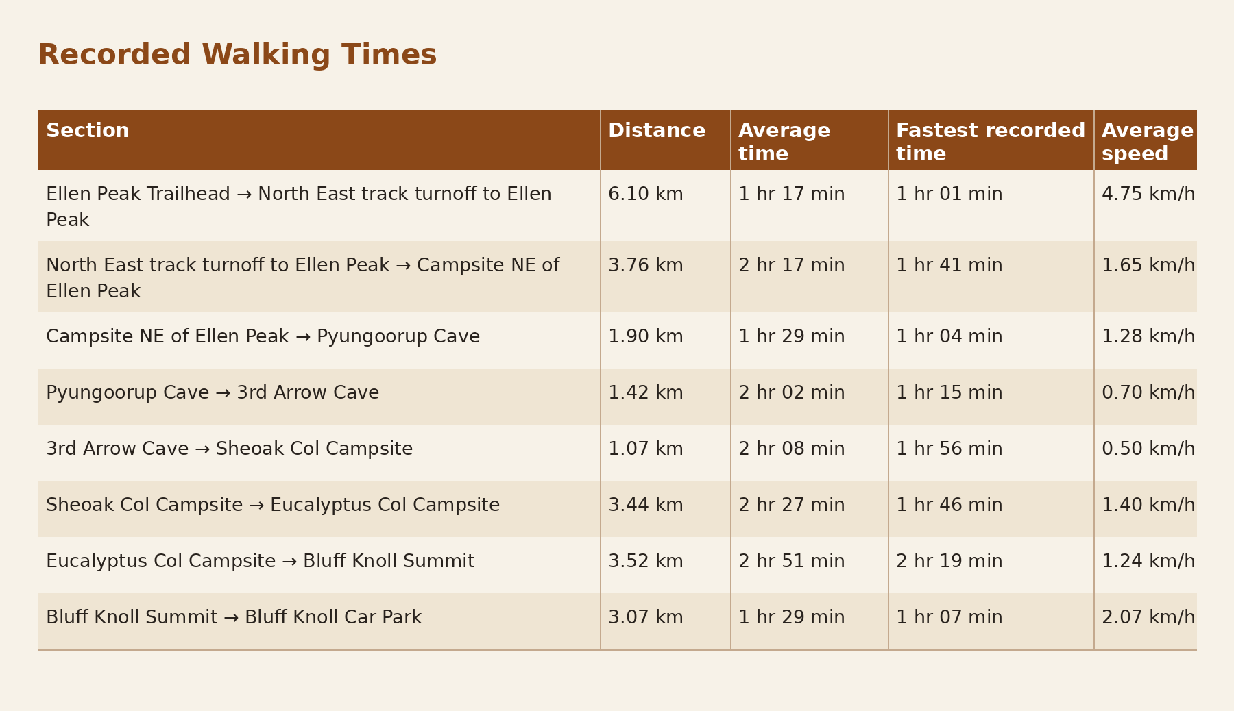
The fastest recorded times shown in this table are the fastest section times that I have personally recorded during my journeys along the SRW. They are not intended to represent the fastest known times for these sections. Other walkers may have travelled through them considerably faster. Their purpose is to provide a comparison with the average times from the journeys used to compile these records.
There is another useful way of looking at these figures. Adding all of the average section times produces exactly 16 hours of recorded moving time from the Ellen Peak Trailhead to Bluff Knoll Car Park. If instead the fastest time I have personally recorded for every section is combined, the total is 12 hours 09 minutes.
This produces a range that is particularly relevant when considering single day traverses. A very strong walker moving efficiently through every part of the route could potentially accumulate section times close to or below the lower end of this range, while the average of the recorded journeys sits at 16 hours of moving time. Actual elapsed time would be longer once substantial food stops, rest periods and other longer interruptions are included.
The approximately four hour difference between these two totals also demonstrates why it would be misleading to give the SRW a single expected completion time. A fast solo walker carrying a light load and moving continuously in favourable conditions is undertaking the route very differently from a multi day group carrying camping equipment. The terrain may be the same, but the resulting travel times can be substantially different.
Distance Does Not Equal Time
Distance is one of the most important pieces of information when planning and monitoring progress on the Stirling Ridge Walk. You need to know how far you have travelled, how far remains to the next significant location and how much distance separates you from the next campsite or suitable place of shelter. What the recorded times demonstrate is that distance cannot be considered by itself. The physical distance needs to be interpreted alongside the terrain through which those kms pass.
This becomes apparent almost immediately when the recorded times are compared. The 6.10 kms from the Ellen Peak Trailhead to the North East track turnoff takes an average of 1 hour 17 minutes, giving an average speed of 4.75 km/h. The fastest recorded time is 1 hour 01 minute. After leaving the North East track turnoff, the character of the journey changes considerably. The next 3.76 kms to the Campsite NE of Ellen Peak takes an average of 2 hours 17 minutes despite being substantially shorter than the initial approach. From the Campsite NE of Ellen Peak to Pyungoorup Cave, another 1.90 kms takes an average of 1 hour 29 minutes.
The effect of the terrain becomes particularly obvious around Pyungoorup Peak and the Arrows. The 1.42 kms from Pyungoorup Cave to 3rd Arrow Cave takes an average of 2 hours 02 minutes. From 3rd Arrow Cave to Sheoak Col Campsite, only 1.07 kms is covered, yet the average recorded time is 2 hours 08 minutes. The average rate of progress through this section is only about 0.50 km/h. The fastest recorded times show that the difference cannot be attributed entirely to slower journeys. Pyungoorup Cave to 3rd Arrow Cave has been completed in 1 hour 15 minutes, while the fastest recorded time from 3rd Arrow Cave to Sheoak Col Campsite is 1 hour 56 minutes. Even during efficient journeys, comparatively little distance is being covered over a considerable period of time.
The contrast with the initial approach is substantial. The 6.10 kms from the Ellen Peak Trailhead to the North East track turnoff has been covered in 1 hour 01 minute. By comparison, only 1.07 kms from 3rd Arrow Cave to Sheoak Col Campsite has taken 1 hour 56 minutes at its fastest recorded time. The difference reflects the very different terrain encountered in these sections rather than the distance shown on the map.
Once on the Ridge, progress is affected by the nature of the ground being crossed. Steep climbing and descending can reduce the rate of travel considerably, and scrambling or broken rock may require much more deliberate movement. Vegetation can slow progress further and there are places where careful foot placement is required. Around the Arrows, navigation becomes an additional consideration because time may be spent identifying features, checking the map and establishing which line through the terrain corresponds with the intended route. A slow rate of travel through these sections does not necessarily indicate that a group is performing poorly.
The figures also show why applying a single average walking speed to the entire SRW has limited value. Recorded averages range from 4.75 km/h on the initial approach to 0.50 km/h between 3rd Arrow Cave and Sheoak Col Campsite. A calculation based on an assumed walking speed might work reasonably well on one part of the journey and be substantially wrong only a few kms later. The terrain between two points determines how useful the distance becomes as an indication of the time required to travel between them.
This matters when monitoring progress during the day. Knowing that the next campsite is 2 or 3 kms away provides useful information, but the distance alone cannot tell you whether reaching it will take one hour or several. Look at what lies between your present position and the intended destination. The map may show substantial climbing or descending, while the Navigation Point information may identify an area where route finding requires greater attention. Your progress over the preceding part of the day provides another useful comparison because it shows how quickly the group is actually moving through the conditions being encountered.
As usable daylight decreases, the difference between distance and time becomes increasingly important. A campsite that appears relatively close on the map may still require several hours of travel if difficult terrain lies between you and it. Two kms remaining while travelling through terrain where progress has been around 0.50 km/h presents a very different situation from two kms remaining on the approach track. The same applies when weather deteriorates. Poor visibility can slow navigation and wet conditions can reduce the rate at which steep or rocky terrain can be negotiated. If the group is already tired, estimates made earlier in the day may no longer reflect the rate at which it is now travelling.
Distance therefore remains an essential part of planning and monitoring progress on the SRW, but it needs to be read in the context of the terrain between your present position and where you intend to go. The recorded section times provide a reference for that assessment, while your actual progress during the journey provides information about how the group is moving on that particular day.
Using the Figures to Consider Different Possibilities
The individual section times can be combined to consider different ways in which a journey along the SRW might be divided. They are not intended to prescribe where you should camp or how many days the traverse should take. They provide a way of comparing distance with recorded moving time and, importantly, with the character of the terrain between possible stopping points.
At the two extremes, the figures provide an interesting comparison. Adding the average section times gives 16 hours of moving time for the complete traverse. Combining the fastest recorded time from each section gives 12 hours 09 minutes. This broadly explains why very strong walkers undertaking a single day traverse may think in terms of something around 12 to 16 hours of moving time, depending on how efficiently they travel and the conditions encountered. Longer breaks would need to be added when considering the total elapsed time for the day. A single day traverse is therefore not a matter of deciding that approximately 24 kms is an achievable walking distance. At the faster end, maintaining progress close to the fastest recorded section times across the entire traverse is a substantial undertaking. At the other end, 16 hours of moving time can place a walker on the Ridge from before sunrise until late in the day, even before significant breaks or delays are considered.
Most walkers divide the SRW over two or three days. A strong two day itinerary might involve travelling from the Ellen Peak Trailhead to 3rd Arrow Cave or Sheoak Col Campsite on the first day, followed by the remainder of the Ridge and the descent to Bluff Knoll Car Park on the second. Reaching 3rd Arrow Cave involves approximately 13.18 kms. Based on the average section times in the table, this represents approximately 7 hours 05 minutes of moving time. Combining the fastest recorded time for each of those sections produces approximately 5 hours 01 minute. Neither figure includes a substantial lunch stop or other longer breaks.
The option of continuing from 3rd Arrow Cave to Sheoak Col Campsite demonstrates particularly well why the remaining distance needs context. Sheoak Col is only another 1.07 kms away, but the average recorded time for that section is 2 hours 08 minutes and the fastest recorded time is 1 hour 56 minutes. Late in the day, looking at the map and thinking that camp is only another kilometre away could give a very misleading impression of what remains. The group would still need to negotiate one of the slowest sections represented in the recorded times.
A three day itinerary provides more flexibility and is broadly representative of many of the trips from which these times were recorded. The first day may extend from the Ellen Peak Trailhead to Pyungoorup Cave or 3rd Arrow Cave, with the second continuing through the Arrows and Sheoak Col to Eucalyptus Col Campsite. The third day continues from Eucalyptus Col through East Peak to Bluff Knoll Summit and then descends to Bluff Knoll Car Park. If the first day finishes at 3rd Arrow Cave, the second day to Eucalyptus Col Campsite covers only about 4.51 kms, yet the combined average moving time is approximately 4 hours 35 minutes. Combining the fastest recorded times gives approximately 3 hours 42 minutes. The third day from Eucalyptus Col Campsite to Bluff Knoll Car Park covers approximately 6.59 kms, with a combined average moving time of approximately 4 hours 20 minutes and combined fastest recorded section times of approximately 3 hours 26 minutes.
The progress made during the first day can provide an early indication of whether the original itinerary remains realistic. If an early start results in the group reaching only the Campsite NE of Ellen Peak by the end of the day, the planned traverse needs to be reconsidered. Much of the slower and more demanding terrain still lies ahead. The pace achieved during the initial approach cannot be projected across Pyungoorup Peak and the Arrows because the recorded times show how dramatically the rate of progress changes once the character of the terrain changes.
The same approach can be used at any point along the Ridge. If you arrive somewhere later than planned, look at what remains rather than concentrating on the time already lost. The distance to the next campsite needs to be considered alongside the recorded times for the sections ahead and what the contours show about the terrain between your present position and that location. Your group's actual progress during the day provides another reference, particularly if fatigue or changing conditions have already begun affecting the rate of travel. The amount of usable daylight remaining may then determine whether the next planned stage is still realistic.
The fastest recorded figures are valuable when making this assessment, but they should not be used to make an optimistic plan work. If reaching the next campsite before dark requires the group to equal the fastest recorded time for the section, there is very little margin available if progress is slower than expected. Navigational uncertainty or deteriorating conditions can consume part of that margin, and the group may already be moving less efficiently after many hours on the Ridge. The fastest recorded time shows what has actually been achieved through that section under favourable circumstances. It does not indicate what a particular group will be capable of achieving when it reaches the same terrain.
Taking longer than the average is also entirely possible and does not necessarily indicate that something is wrong. The recorded journeys were undertaken under different circumstances. Some involved solo travel and others groups, while the amount of time spent taking photographs, collecting water or examining the terrain also varied. Weather, vegetation and the amount of navigation required could change from one journey to another. The figures provide reference points against which the progress of the current journey can be compared rather than a timetable that needs to be matched.
There are many other ways of undertaking parts of the SRW. Some walkers undertake Ellen Peak as a return day walk from the trailhead, while others camp near Ellen Peak and return the following morning. Suitably experienced and very fit walkers may undertake a half ridge journey in a day, and different camping locations can alter the balance between days considerably. The section times can be combined according to the journey being considered rather than requiring the walk to fit one predetermined itinerary.
Direction of travel also needs to be considered. These figures describe travel from the Ellen Peak Trailhead towards Bluff Knoll. Travelling towards Ellen Peak changes the way the terrain is encountered and presents navigational features from a different perspective. A climb in one direction becomes a descent in the other, while scrambling sections may be approached very differently. The recorded times should therefore not automatically be applied in reverse.
Before the trip, the figures can be used to compare possible stages and examine how much moving time may be contained within apparently short sections. Once on the Ridge, they provide a reference against which the original plan can be compared with the progress actually being made. If the intended stopping point is still several sections away late in the day, the relevant question is not only how many kms remain. The terrain contained within those kms and the time that similar journeys have required to cross it become part of the calculation.